

-
 .
.
A pair of virtual public meetings with in-person options for the proposed U.S. 69 Lumberton-Kountze Relief Route has been set for next month by the Texas Department of Transportation (TxDOT) Beaumont District.
According to TxDOT, the first meeting is 6 – 8 p.m. on Tuesday, April 2 at the Cruse-Wilson Gym at Kountze High School, 1488 FM 1293. The second is 6 – 8 p.m. on Thursday, April 4 at the Lumberton ISD Performing Arts Center, 105 South LHS Dr.
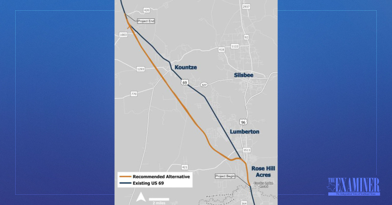
The meetings are to gather input on the proposed route that stretches 23 miles from Cooks Lake Road, south of Lumberton, to FM 420, north of Kountze. U.S. 69, a north-south highway from Port Arthur to Denison, is designated as a hurricane evacuation route.
The virtual meeting will consist of a pre-recorded video presentation including both audio and visual components. In-person attendees will be able to view the same presentation delivered in the virtual public meeting, review hard copies of project materials, and ask questions of TxDOT staff and/or consultants.
The proposed project would, subject to final design considerations, require 9,400 acres of right-of-way.
According to Public Information Officer Tanya Avila, of the TxDOT Beaumont District, the upcoming pub- lic meetings will show a revised recommended route, wherein TxDOT took into consideration from comments made at the May 2023 public meeting and has incorporated them into the revised route. She noted the consultant is still finalizing some items ahead of the public meeting and the proposed route will not be available for public viewing until March 18.
Ellen Buchanan of the Big Thicket Natural Heritage Trust said the project is a “completely new road through 60% of floodplain and wetlands.”
Avila stated TxDOT began looking into a relief route around Lumberton and Kountze in 2022.
Based on public input received during the May 2023 public meetings, TxDOT eliminated the previous alternatives from further study and has developed a revised recommended alternative for public review and input. Originally, the district proposed to construct a U.S. 69 relief route from Cooks Lake Road to FM 1003.
The 20.2-mile proposed project included a new location roadway that would require 325 feet of right-of-way width.
The ultimate roadway includes two 12-foot lanes in each direction, a northbound 13-foot outside shoulder to be used as a hurricane evacuation lane, and a southbound 10-foot outside shoulder. The project will also include two-lane frontage roads in each direction. Bicycle and pedestrian accommodations were considered.
The purpose of the U.S. 69 feasibility study is to provide a relief route to support safe and efficient north/south movement of people and goods between Beaumont and Woodville.
“Like any project, there are always challenges that we must consider, things like right of way acquisition, utility challenges, environmental concerns, overall benefit to the region, among others,” said Avila. “We are, however, still in the very early stages of developing this proposed project. Once a final route is determined, we will be able to begin environmental studies and start designing the actual roadway.”
Currently, the project is not fully funded.
“We will not have an estimated cost on this project until we are further along in the design process,” she said.
The public meetings will be conducted in English. If you need assistance, special arrangements can be made to accommodate most needs. Contact Avila at (409) 898-5745, no later than 4 p.m. on March 27.
Advance notice is required as some services and accommodations may require time for the TxDOT to arrange.